(this whole post has some kind of weird formatting html problem I can't be bothered to figure out right now. Sorry for all the underlining . . . )
Yesterday I went out to replicate a favorite long run that I have not done since last year. Tom dropped me off at Stampede reservoir, and I ran about 10 trail miles to my previously stashed car at Donner Camp -- this is the Emigrant Trail, and it's got to be one of the loveliest runs around these parts, and that's saying a LOT.
I ran this once or twice last year, and remember it as being challenging, yet relatively easy and quite a fun run. I must have been in better shape then, 'cause while it was definitely fun, it was really quite challenging for me, especially those pesky first few miles. Throughout the run, I stopped a number of times and took quite a few walk breaks, which I generally don't do unless there's lots of big hills. There is quite a bit of climbing on this run (Gary says 1761, which seems a little high, but I'm not gonna argue), but it's all pretty gradual, and not the type of climb that usually makes me stop or walk. I was just feeling kinda tired (maybe over-training a bit?) and took the opportunity to take lots of photos. Also, I've just made the switch from iPhoto to Picasa, so the shots are an experiment in uploading (I think they should be bigger -- next time!) Hopefully, all the captions line up . . .


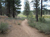
This is such a beautiful run, and most of the trail looks pretty much like this -- nice, clear dirt path through lovely pines. I took off around 10:30 am, which was perhaps a bad choice this day as it was HOT and got HOTTER. I usually run in the afternoon/evening, so this high noon stuff was a little tricky for me.


The heat the climbing took its toll, and I was not a happy camper the first 4 miles. I found all kinds of reasons to stop!
There were plenty of wildflowers everywhere. I think this was about halfway through the run. I dunno the name for these, but they were a really vivid blue that was hard to capture with my little point and shoot camera.
Most of the trail runs through the forest, but at the peak you can catch glimpses of the surrounding mountains. This is looking east towards Reno.
Anyhow, by this point I am enjoying my run, as I am well into the downhills and (what passes for) flats. Unfortunately -- and this is rare for me -- I have just about run out of water at this point, and am on total rations. One tiny sip! Not pleasant when it's 85 degrees or whatever.
This is the only really open part of the trail, and the run through the meadow is a nice change. I took my very last sip of water here.
Water, water everywhere. This is Martis Creek, and this time last year was fairly easy to cross with dry feet, stepping from stone to stone. Another effect of all the rain we had earlier is this:
I could have taken my sneaks and socks off, but I figured with only 2 miles left wet feet couldn't do too much damage. The water felt WONDERFUL!
Again, somehow Gary calls this 1700 feet of elevation gain, but that just seems excessive. I've got to look at that a little closer. I'm using a program called Ascent to manage the GPS input, and I'm finding it just slightly bewildering.
All in all, a fine run, though slow. I ran 10 or 10.5 miles (had some GPS issues right at the start and had to start it over again) in about 2:30.
I am so fortunate to live in such a beautiful place. The pictures really don't do it justice . . .


3 comments:
Photos look gorgeous! Thanks for the headsup on Ascent, it looks pretty good especially as GTC for the Mac sucks and I am not 100% on Garmin Connect
Any other thoughts on the program?
I love the pics of your run, it looks awesome. Well done in the heat.
Lovely photos!! Back in college, I used to have a boyfriend whose family had a cabin up in the Truckee area that we used to go to several times a year. Some of those names (Stampede Res., Donner Lake, Emigrant Trail) sound familiar. I wasn't a very serious runner back then but did a lot of hiking and I'm sure I've been there before like ~20 yrs ago.
Post a Comment